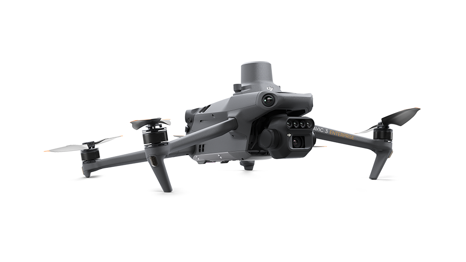
DJI Mavic 3 Enterprise Multispectral Drone
Brand: DJI
SKU: 591542
Category: Electronics > Drones
Price: RM 32863.00
Dealer Price: RM 32863.00 (for bulk orders)
Availability: 3-7 days
Product Description
Effective aerial surveying needs to see the invisible. That's why Mavic 3 Multispectral has two forms of sight. It combines an RGB camera with a multispectral camera to scan and analyze crop growth with total clarity. Agricultural production management requires precision and data, and Mavic 3M delivers both. Highly integrated imaging system - Newly upgraded imaging system with one 20MP RGB camera and four 5MP multispectral cameras (green, red, red edge, and near infrared). Enables applications such as high-precision aerial surveying, crop growth monitoring, and natural resource surveys. Sunlight Sensor - The built-in sunlight sensor captures solar irradiance and records it in an image file, allowing for light compensation of image data during 2D reconstruction. This results in more accurate NDVI results, as well as improved accuracy and consistency of data acquired over time. Accurate images that capture every pixel - Mavic 3M with RTK module for centimeter-level positioning. Flight control, the camera, and the RTK module sync in microseconds to accurately capture the location of each camera's imaging center. This enables Mavic 3M to do high-precision aerial surveying without using ground control points. Ultra-long battery life, fast bursts 43 minutes - Cruise time 200 hectare - A single flight can complete mapping operations over an area of 200 hectares. Stable signal, smooth image transmission - The O3 transmission integrates two transmitting signals and four receiving signals to support 15km ultra-long transmission distances. Omnidirectional obstacle sensing, terrain-follow aerial surveying - The aircraft features multiple wide-FOV vision sensors that accurately detect obstacles in all directions for omnidirectional obstacle avoidance. The terrain-follow aerial surveying can be easily performed in steep-slope landscapes. Orchard mapping - Mavic 3M allows terrain-follow aerial surveying of orchards, even on sloped landscapes. Together with DJI Terra or DJI SmartFarm Platform to reconstruct high-resolution orchard maps, automatically identify the number of trees, distinguish trees from other obstacles or objects, and generate three-dimensional operation routes for agricultural drones, making operations safer and more efficient. Guide variable rate applications - For rice fertilization, cotton growth regulation, and potato foliar fertilizer spraying, the Mavic 3M is used to obtain multi-spectral images of crops. DJI Terra or the DJI SmartFarm Platform can then generate NDVI and other vegetation indices maps, capturing differences in crop potential and generating prescription maps that allow agricultural drones to execute variable-rate application. This ultimately allows users to reduce costs, increase yield, and protect the environment. Intelligent field scouting - The Mavic 3M can carry out automatic field scouting. The field scout images can be uploaded to the DJI SmartFarm Platform in real time through a 4G network. It can find abnormalities, such as emergence deficiencies, weed pressure, and crop lodging in a timely manner. It can also conduct intelligent analyses, such as cotton seedling identification and rice production testing, using AI identification for real-time sharing of crop growth information, guidance of agronomic activities, and easy management of 70 hectares of farmland by one person. Specifications Aircraft Net Weight (with propellers and RTK module) [1] 951 g Max Takeoff Weight 1,050 g Dimensions (Folded/Unfolded) Folded (without propellers): 223×96.3×122.2 mm (Length×Width×Height) Unfolded (without propellers): 347.5×283×139.6 mm (Length×Width×Height) Diagonal Length Diagonal: 380.1 mm Max Ascent Speed 6 m/s (Normal Mode) 8 m/s (Sport Mode) Max Descent Speed 6 m/s (Normal Mode) 6 m/s (Sport Mode) Max Flight Speed (at sea level, no wind) 15 m/s (Normal Mode) Flying forward: 21 m/s, flying sideways: 20 m/s, flying backwards: 19 m/s (Sport mode) [2] Max Wind Speed Resistance 12 m/s [3] Max Take-off Altitude Above Sea Level 6000 m (without a payload) Max Flight Time (without wind) 43 minutes [4] Max Hover Time (without wind) 37 minutes [4] Max Flight Distance 32 km [6] Max Tilt Angle 30° (Normal Mode) 35° (Sport Mode) Max Angular Velocity 200°/s GNSS GPS + Galileo + BeiDou + GLONASS (GLONASS is supported only when RTK module is enabled) Hovering Accuracy Range Vertical: ±0.1 m (Vision Positioning enabled); ±0.5 m (GNSS Positioning enabled); ±0.1 m (D-RTK enabled) Horizontal: ±0.3 m (Vision Positioning enabled); ±0.5 m (HD Positioning enabled); ±0.1 m (RTK enabled) Operating Temperature -10° to 40° C (14° to 104° F) Internal Storage N/A Motor Model Number 2008 Propeller Model Number 9453F Enterprise Edition Light Sensor Built-in module RGB Camera Image Sensor 4/3 CMOS Effective Pixels: 20 MP Lens FOV: 84° Equivalent focal length: 24 mm Aperture: f/2.8 to f/11 Focus: 1 m to ∞ ISO Range 100-6400 Shutter speed Electronic shutter: 8-1/8000 s Mechanical shutter: 8-1/2000 s Max Image Size 5280×3956 Photo Shooting Mode Single shot: 20 MP Timelapse: 20 MP JPEG: 0.7/1/2/3/5/7/10/15/20/30/60 s JPEG + RAW: 3/5/7/10/15/20/30/60 s Panorama: 20 MP (original material) Video Resolution H.264: 4K: 3840×2160@30fps FHD: 1920×1080@30fps Max Video Bitrate 4K: 130Mbps FHD: 70Mbps Supported File System exFAT Image Format JPEG/DNG (RAW) Video Format MP4 (MPEG-4 AVC/H.264) Multispectral Camera Image Sensor 1/2.8-inch CMOS, effective pixels: 5 MP Lens FOV: 73.91° (61.2° x 48.10°) Equivalent focal length: 25 mm Aperture: f/2.0 Focus: Fixed Focus Multispectral Camera Band Green (G): 560 ± 16 nm; Red (R): 650 ± 16 nm; Red Edge (RE): 730 ± 16 nm; Near infrared (NIR): 860 ± 26 nm; Gain Range 1x-32x Shutter Speed Electronic Shutter: 1/30~1/12800 s Max Image Size 2592×1944 Image Format TIFF Video Format MP4 (MPEG-4 AVC/H.264) Photo Shooting Mode Single shot: 5 MP Timelapse: 5 MP TIFF: 2/3/5/7/10/15/20/30/60 s Video Resolution H.264 FHD: 1920 x 1080@30fps Video content: NDVI/GNDVI/NDRE Max Video Bitrate Stream: 60 Mbps Gimbal Stabilization System 3-axis mechanical gimbal (tilt, roll, pan) Mechanical Range Tilt: -135° to 45° Roll: -45° to 45° Pan: -27° to 27° Controllable Range Tilt: -90° to 35° Pan: Uncontrollable Max Control Speed (tilt) 100°/s Angular Vibration Range ±0.007° Sensing System Sensing System Type Omnidirectional binocular vision system, with an infrared sensor at the bottom of the aircraft Forward Distance Measuring Range: 0.5 m to 20 m Detection Range: 0.5 m to 200 m Effective Obstacle Avoidance Speed: Flight Speed ≤15 m/s FOV: Horizontal 90°, vertical 103° Backward Distance Measuring Range: 0.5 m to 16 m Effective Obstacle Avoidance Speed: Flight speed ≤12 m/s FOV: Horizontal 90°, vertical 103° Lateral Distance Measuring Range: 0.5 m to 25 m Effective Obstacle Avoidance Speed: Flight speed ≤15 m/s FOV: Horizontal 90°, vertical 85° Upward Distance Measuring Range: 0.2 m to 10 m Effective Obstacle Avoidance Speed: Flight Speed ≤6 m/s FOV: Front and rear 100°, left and right 90° Downward Distance Measuring Range: 0.3 m to 18 m Effective Obstacle Avoidance Speed: Flight speed ≤6 m/s FOV: Front and rear 130°, left and right 160° Operating Environment Front, Rear, Left, Right, Above: Surfaces with clear patterns and adequate lighting (> 15 lux, environments with normal indoor fluorescent light exposure) Below: Surfaces with diffuse reflection material and a reflectivity of >20% (such as walls, trees, people, etc.); Adequate lighting (>15 lux, environments with normal indoor fluorescent light exposure) Video Transmission Video Transmission System DJI O3 Image Transmission Industry Edition Live View Quality Remote Controller: 1080p/30fps Operating Band [7] 2.400-2.4835 GHz 5.725-5.850 GHz Max Effective Signal Distance (Unobstructed, No interference) [8] FCC: 15 km CE: 8 km SRRC: 8 km MIC: 8 km Max Transmission Distance (Obstructed) [9] Strong Interference (urban landscapes, residential areas, etc.): 1.5-3 km (FCC/CE/SRRC/MIC) Medium Interference (suburban landscapes, city parks, etc.): 3-9 km (FCC), 3-6 km (CE/SRRC/MIC) Weak Interference (remote fields, open farmland, etc.): 9-15 km (FCC), 6-8 km (CE/SRRC/MIC) Max Download Speed 15 MB/s (with DJI RC Pro Industry Edition) Latency (depending on environment and mobile device) Approximately 200 milliseconds Antennas 4 antennas, 2 transmitting and 4 receiving Transmitter Power (EIRP) 2.4 GHz: <33 dBm (FCC), <20 dBm (CE/SRRC/MIC) 5.8 GHz: <33 dBm (FCC), <30 dBm (SRRC), <14 dBm (CE) Other Supports the DJI Cellular module In The Box :- - 1 x Aircraft (microSD card installed - Sandisk Extreme Pro 128GB MicroSD Card) - 1 x RTK Module - 1 x Mavic 3 Intelligent Flight Battery - 1 x Gimbal Cover - 1 x DJI RC Pro Enterprise - 1 x Power Cable - 1 x USB-C Cable - 3 x Pair of Low-Noise Propellers - 1 x Charger - 1 x USB-C to USB-C Cable - 1 x Carrying Case - 1 x Screwdriver - 1 x Manuals - 1 x DJI Combo A - Mavic 3 Series
Product Features
- Quality assured industrial and office supplies
- Available for B2B wholesale purchase
- Genuine DJI product
- Fast delivery across Malaysia
- Competitive wholesale pricing for businesses
Order Now
Ready to order DJI Mavic 3 Enterprise Multispectral Drone? View product details and add to cart for fast delivery to your business.
For bulk orders and dealer pricing, register a business account today.